

The 61-mile long High Sierra Trail has the unfortunate distinction of being both overshadowed by the John Muir Trail and frequently confused with the rugged and mainly off-trail Sierra High Route. It is quite a trail in its own right however, crossing the Southern Sierra Nevada from Crescent Meadows in Sequoia National Park to its terminus at the summit of Mount Whitney. While the scenery is exceptional by most standards, it does not quite measure up to the continually mind-blowing awesomeness and variety of the JMT, or the rugged alpine character of the SHR. However, compared to the JMT, the HST has the advantages of being less crowded, shorter, and easier to get a permit for. The High Sierra Trail actually joins the JMT at Wallace Creek for the final 11 miles to the summit of Mount Whitney, which is the only section of the HST that I had done prior to this trip.
Most people who backpack the HST seem to go from West to East, taking a few days to a week to cover the 72 miles (including the 11 mile descent from Mount Whitney to the trailhead at Whitney Portal which is not part of the “official” HST). This typically involves either a 300-mile car shuttle, or getting dropped off at the start and picked up at the end. For this reason, as well as its relatively short length, I decided it would be a fun challenge to do a Yo-Yo (ie round-trip) on the High Sierra Trail.

The Yo-Yo approach eliminates both the car shuttle and the steep, crowded 11-mile descent on the Whitney Trail, leaving an aesthetic 122-mile double crossing of the Southern Sierra, with the mid-point being the highest point in the continental U.S.
According to the FKT website, a handful people including Leor Pantilat, Brett Maune, Brian Robinson and Peter Bakwin have run the HST from East to West, and at least one has tried a West to East run. Although she skipped the 4 mile section to the summit of Mount Whitney, Sarah’s Thompson’s time of 23:05 going West to East (the harder direction) is still impressive. Leor’s very fast time of 15:46 from Whitney Portal to Crescent Meadows is the current FKT, while Brett’s previous FKT of 18:39 seemed like a more reasonable approximation of what might be possible for me on a one way trip.
There were no reported round trip times in either direction, but I estimated that it would take me about 36-40 hours, if all went well. While perhaps a bit optimistic, this was right at the limit of what I thought I could do without sleep, so hiking through the night instead of carrying camping gear and stopping to sleep seemed like a no-brainer – as long as the weather was stable. As an added bonus, since I would be hiking in both directions, any scenery that I missed in the dark I would see in the daylight on the return trip, and vice versa – and if I timed it right, I could see the sunrise from the summit of Mount Whitney at the halfway point. Also, since I would not be “camping” I would not have to worry about getting a wilderness permit or carrying a bear canister.
Given all this, I could hardly believe that no one had done it already – or if someone has they did not report it on the FKT website. Regardless, I decided to go for it, when the time and the weather forecast were right. And so it was that I found myself packing for another solo trip to the mountains.
I drove to Sequoia the afternoon of Friday August 12, and managed to get the second to last campsite in the park. I got a good 10 hours of sleep and woke up at 6:30, planning to start between 8:30-9:30 am, hoping to arrive at the summit of Mount whitney around 6:30am for sunrise. I had a big breakfast, packed up my camp and tried to drive to the Crescent Meadows trailhead, only to find that the road is closed on weekends and you have to take a shuttle bus to the trailhead. However, if you have a wilderness permit you can park at the trailhead.
So I had to drive back to the permit office at Lodgepole, and explain my rather unconventional trip plan to the ranger, in order to get an overnight wilderness permit for my dayhike, all so I could drive to the trailhead and my car would be waiting for me there when I finished my epic in the middle of the night.
I told the ranger I was going to Wallace Creek, and would either turn around there, or go all the way to Whitney and back if I was feeling good. This was all true – my backup plan was to turn around at Wallace Creek or any point along the way if things were not going as planned, and I knew that I could bail at Whitney Portal if necessary. Realizing the mileage involved, the ranger seemed a bit skeptical, but his main concern was that I would not leave any food wrappers on the trail – he mentioned that they have had problems with runners leaving trash behind. I assured him that I am always super careful to pack out my trash, and he issued the permit.
As a result of all this, I didn’t start till 10:30 am. I planned to be out for 36-40 hours and brought enough food to have 200 calories per hour for 37 hours – about 24 Clif shot blocks with a bunch of Clif and Honey Stinger gels and 4 Lara bars, or 7400 calories total. With rain jacket and pants, hat, gloves, phone, map, 1L water and a few other odds and ends my Ultimate Direction AK running pack weighed about 10 lbs starting out.
The first 11 miles or so to the Bearpaw Meadow High Sierra Camp was very dry and dusty, rolling and fairly easy trail, and I enjoyed running quite a bit of it at an easy pace, trying to conserve energy while covering the easy miles as quickly as possible. I reached Bearpaw Meadow at mile 11 feeling good. A few miles later I reached Hamilton lakes and started climbing up towards Kaweah gap. The scenery started getting good and the climbing felt easy with my light pack. I started passing backpackers and eventually reached the beautiful Precipice Lake, which I instantly recognized from Leor’s pictures.


Before I knew it I was at Kaweah Gap, 20 miles in and only 100 miles to go. I checked my watch and the elapsed time was 5:38. This may seem like an overly fast pace, and it may have been, but I knew that when it got dark I would slow down quite a bit and I wanted to cover as much ground in the daylight as possible.
Somewhere along the way I started feeling a hotspot on the ball of my left foot. I stopped to check it and realized that it was not a blister, but so much fine dust had gotten through my gaiters, shoes, and 2 pairs of socks that my feet were black and the dust had accumulated under my foot and was slowly rubbing it raw. I cleaned up as best I could and put a second skin bandage on it and continued. Over the next few hours I had to stop numerous times for foot care due to the amount of dust that was getting into my shoes. I used up most of my blister care supplies in an effort to prevent minor issues from becoming major ones, realizing a bit too late that I should have brought a fresh roll of Leukotape. The small roll I have had in my blister kit for a year or more had degraded to a useless, sticky mess. Fortunately I also had a few scraps of kinesiotape which was just enough to do the trick.
From this point on, the amount of running I was able to do was quite limited – I was pretty sure that if I ran much I would end up with bad blisters before the halfway point, and may not be able to finish. My primary goal was to finish the HST Yo-Yo – time goals were secondary and I did not want to make any mistakes that would force me to bail or make finishing more painful than necessary. And anyway it was going to be getting dark soon, so I resigned myself to a fast hiking pace for the foreseeable future.
I’m guessing that since I was only carrying a daypack, I was running more than I usually do on my long efforts, which kicked up more dust than usual. I’ve spent a lot of time on the JMT, which is also a fairly dusty trail, but this seemed quite a bit worse than usual. If I was going to do this trail again I would seriously consider drastic measures to keep the dust out as that was definitely the limiting factor.

It got dark as I was nearing the Lower Kern Canyon Junction at Funston Meadow (mile 35, elapsed time 10:09). Only 25 miles to go to Whitney, and then another 60 to get back to the start! I hiked up through Kern Canyon in the dark, thankful that it was cool but thinking that it would have been nice to be able to see it in the daylight and perhaps run some of the smooth, relatively flat trail through this reportedly very nice section. But no matter, I would be back soon enough in full daylight!
I reached Wallace Creek at around mile 49, elapsed time 14:54 and was elated to realize that I had less than 12 miles to go. I felt good enough to continue, so off I went.

I reached Crabtree – still in the dark of course – (mile 53, elapsed time unknown) and continued on. As I neared Guitar lake I saw the familiar line of headlamps making their way up the backside of Whitney – the convergence of JMT hikers finishing their 2-4 week treks and Whitney hikers, all trudging their way up to see the sunrise from the highest point in the lower 48. It was just staring to get light as I reached Trail Crest, and it was cold enough that I put on my rain jacket and vest, and soon stopped again to put on my rain pants. I was now wearing all the clothing I had (including hat and gloves), hiking fast uphill, and still a bit cold. It is chilly up there at dawn!
As I passed by the first windows down to the east side, I caught a few glimpses of the sunrise, but by the time I reached the summit the spectacle was over and day had broken. I had missed sunrise on the summit by about 15 minutes!


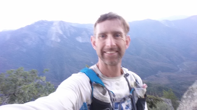
Not wanting to make a spectacle of myself, I only mentioned what I was doing if someone asked, so most of the people on the summit likely assumed I was just another dayhiker. The few people I told what I was doing had a hard time comprehending, which is to be expected – I still wasn’t sure how or if I was going to be able to finish this thing, but I was at the halfway point, feeling pretty good overall, and it was daylight again, so I had a few things going for me! Elapsed time on arrival at Whitney summit was 20:06 (10:30 am to 6:36 am) and I stayed there for 20 minutes, heading back down at 6:56am.
I stopped at one of the Tarns above guitar lake to take care of my feet, and used up the last of my blister prevention/treatment supplies. As it turns out this was the last time I took off my shoes as well, but I did have some decent sized blisters by the end of the hike. I figured there wasn’t much I could do to stop them at this point so I just popped 3 ibuprofen every 6 hours and pushed on.

By the time I reached the Kern Canyon again it was midday and kind of a furnace, or it would have been quite pleasant. I eventually remembered to dip my hat in the streams and get my hair wet, which helped cool me down a bit. Periodically I passed some backpackers; most didn’t ask questions beyond the usual “how’s it going” but I got some interesting looks as they tried to figure out what the hell I was doing so far out there with such a tiny pack. I still felt surprisingly good at this point considering I was about 80 miles in with 40 more to go, although the heat was definitely taking a toll. I am not sure of the time or exact location here but it was probably in the 28-30 hour range.


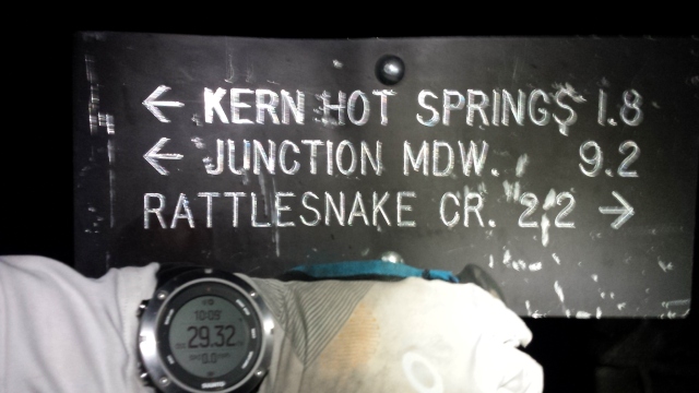
Eventually I passed the Kern Hot Springs (I had missed it in the dark on the way in) and thought about stopping for a dip. At this point I was so hot that the cold river sounded a lot better, but with 37 miles to go I didn’t want to take the time to stop and take my shoes off, so I kept going. All my focus now was on getting back to the car, real food, sleep, clean clothes.
It started to cool down, the pressure dropped, and a restless wind bounced around the canyon. The huge trees around me were suddenly swaying and groaning, and a pine cone with a tuft of needles still attached landed at my feet. I was reminded of the many dead branches and dead trees swaying high above me, just waiting for the right push from the wind to let go and come crashing down to earth.
The storm alarm on my watch started beeping insistently. I examined the sky and saw a few clouds behind me to the north, and clear blue sky everywhere else. It didn’t look like a storm was coming, and in my state I sure hoped it wasn’t – but it was a bit disconcerting to say the least. Fortunately the wind soon died down and I headed up and out of Kern Canyon, thankful for the breeze and the slightly cooler temperatures.
I wanted to get as far as I could in the daylight before darkness and sleep deprivation joined forces to throw me off course – I knew it could get ugly real quick and the longer I was out here the more likely I would be to get lost or screw up in any number of other ways. So I doggedly plodded up out of Kern Canyon and onto the Chagoopa Plateau in the evening light. It was dark well before I reached Kaweah gap, but I knew once I got there I had only 20 miles to go. It didn’t really register that I had just hiked 100 miles in one push – all my focus was now on staying upright, and continuing to move forward.
Once it was dark my balance started to go. I found that when I turned my head to look at something, I would get a little dizzy when I turned back and have to stop to keep from falling over. As much of this section is on a trail that is less than 3 feet wide, with a huge dropoff on one side, I tried to focus on staying right, and not falling off the cliff on the left.
This was all familiar and expected after my JMT efforts last year, so I didn’t worry too much, just tried to stay focused on the trail and not to look around more than necessary. This is harder than it sounds. Rocks look like tents, trees look like people, all sorts of animals make noises in the woods, and in the dark there is a constant desire to look around and get your bearings. At one point a bird flew out of a bush as I brushed past and flapped and squawked angrily at my head, defending it home from the unbalanced intruder who had the nerve to disturb its home. I ignored it and kept moving.
Heading down past Precipice Lake towards Hamilton Lakes, I started having some serious thoughts about rocks. I literally remembered nothing about this section of trail, and could not believe how many rocks there were. In my mind for hours I had been envisioning a smooth if somewhat dusty last 20 miles back to the car. I remember thinking that there were just too many rocks, they looked like all the other rocks I had already been over and I had already seen quite enough rocks and I did not order these rocks! Still the rocks just kept coming. I was so sick of stepping over, on, and around these pointy, unbalanced, poorly arranged rocks with my battered, blistered, and tired feet.
I also had periodic episodes where I would forget why my feet had to keep stepping on the rocks, it seemed there had to be a better way and it all seemed so pointless and interminable. And yet the rocks continued. My knees hurt, my feet hurt – oh yeah, it must be time for ibuprofen again. My food supply was starting to run low so I switched from eating every 30 minutes to every 45-60 minutes. I started checking the map more often to make sure I did not get lost and knew where the next water would be. The trail seemed to go on forever, but eventually I reached Bearpaw meadow and filled up both my bottles for the final 11 mile stretch. This also went on forever. Every little hill was a struggle – and there were LOTS of little hills. The trail at this point is pasted on to a steep hillside/cliff and goes up and down over and over again as it winds in and out of innumerable side canyons.
Sometime around 4am my headlamp battery died suddenly (this was battery #2 so I was glad I had decided to bring battery #3 at the last minute). I changed it in the light of the moon and continued on. I saw a smallish bear on the hillside above me foraging for food, and decided that this was a good omen.
Around 5:30am it started to get light in the forest and the birds woke up and began making cheerful noises, which lifted my spirits a bit. I turned off the headlamp and put it away. I had now hiked through two full nights, and dawn was here again. I had to be close but the trail just kept going on and on. I was now checking my GPS app on my phone compulsively to make sure I was still on the right trail. I was, but it simply refused to end. Eventually I got to Eagle View and realized with both both horror and relief that I had one more mile to go.

Then it was over and I had to decide whether to eat, sleep or shower first, and where and how and in what order. I managed to drive to Lodgepole without crashing, took my shoes and filthy clothes off, examined my swollen feet, got some food and a shower, found a place to sleep for a few hours and then drove home. All told I was awake for 54 hours straight, moving more or less continuously for about 44 hours, covering 122 miles and approximately 28,000 feet of ascent and another 28,000 feet of descent.
Crescent Meadows to Whitney Summit: 10:30AM to 6:36 AM (20:06)
Whitney Summit to Crescent Meadows: 6:56AM to 6:32 AM (23:36)
Total time 44:02
It was a grand adventure, and one that I will not be repeating anytime soon.
Gear:
- Ultimate Direction AK pack with 2 UD body bottles (worked great, highly recommend)
- BD distance carbon poles
- Altra Olympus 2.0 shoes
- Injinji toesocks plus farm to feet wool socks
- Dirty Girl gaiters
- CEP calf sleeves
- Nike running shorts
- Patagonia Capilene 1 long sleeve shirt
- Ultimate Direction sun hat
- Montane Pullover rain jacket
- Homemade synthetic vest
- Patagonia Alpine Houdini rain pants
- Mountain Hardwear powerstretch beanie
- OR warm running gloves
- OR fingerless sun gloves
- Zebralight headlamp with 3 CR123 batteries
- Ibuprofen, caffeine pills, salt tablets, 2 starbucks via packets
- lip balm and sunscreen
- small blister kit
- TP and ziplock baggies
- Phone with US Topo GPS app (not the best app but it works)
- Paper Map
- Suunto Ambit3 Peak GPS watch
- Food – 24 packages of clif shot blocks, 4 lara bars, and about 18 gel packets (consumed all but 3 of the lara bars)
GPS track:
[edit 12/4/2016: Original GPX files were sent to Peter Bakwin and Adam White for verification etc shortly after this trip. Adam combined the two files into one GPX file and using programming magic, added data points exactly halfway between each existing data point in both time and space, in order to increase the accuracy of the Strava data for per mile pace etc as it was wildly inaccurate in the original files due to the 1 minute GPS sampling rate I used in order to preserve battery life on my GPS watch.]

Allen, awesome effort and great write up! Congrats!
Bill
LikeLike
Wow. You are so inspiring Allen! You continuously amaze me!
LikeLike
Truly an outing in the spirit of old-school ultra running! I have a hard enough time putting up with the Sierra’s rocky pack-trails even when I’m not blistered and hallucinating…
LikeLike
FYI re parking at Crescent Meadows: In summer high season, you can drive the road either before 7am or 8am (I forget).
LikeLike